
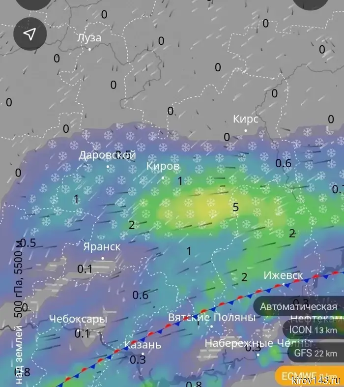
At the end of the week, heavy snowfalls may hit the Kirov region.
The authors of the Telegram channel "Amateur Meteorology in Kirov" analyzed the operational forecast of the ECMWF model. According to the map, an atmospheric front is passing through the Kirov region, forming a band of precipitation from Darovsky through Kirov and further east.
Intensity: in the Kirov area — about 1 mm of precipitation, to the south and southeast — up to 5 mm (yellow zone). Snow is expected almost everywhere, with wet snow or a transition to rain possible closer to the front. The northern part of the region (Luzha and northward) remains without precipitation — it is drier and colder there. The wind is from the west and southwest, bringing warmer air to the front.
The message states: "Strong and moderate snowfalls may begin on the night of April 19 from the southern half of the region. This is currently the most negative of possible scenarios. According to other model calculations, snowfalls are virtually excluded. We are monitoring the situation."
Thus, snow in the region is possible but not guaranteed. Amateur meteorologists continue to monitor the developments.
Другие Новости Кирова (НЗК)
 The traces of the billion-dollar embezzlers Kintzler led to the convicted Colonel Voronov.
A bankrupt trust, co-owned by Yuri Kintzler (a person from the Forbes list), lost about half a million rubles from the bankruptcy estate. There is evidence of theft; however, arbitration courts refuse to return the property due to the expiration of the statute of limitations.
The traces of the billion-dollar embezzlers Kintzler led to the convicted Colonel Voronov.
A bankrupt trust, co-owned by Yuri Kintzler (a person from the Forbes list), lost about half a million rubles from the bankruptcy estate. There is evidence of theft; however, arbitration courts refuse to return the property due to the expiration of the statute of limitations.
 In Omutninsk, Luza, and Vondanka, houses were on fire, and near Yaran, a moose was hit.
In the Kirov region, there were 10 fires and four traffic accidents in a day.
In Omutninsk, Luza, and Vondanka, houses were on fire, and near Yaran, a moose was hit.
In the Kirov region, there were 10 fires and four traffic accidents in a day.
 Nikita Gorelov was accused of usurpation of power and a military coup.
The head of the administration of the city of Sosnovka called the statements from fellow citizens, which are regularly sent to law enforcement agencies, "systematic harassment" and "asymmetric pressure."
Nikita Gorelov was accused of usurpation of power and a military coup.
The head of the administration of the city of Sosnovka called the statements from fellow citizens, which are regularly sent to law enforcement agencies, "systematic harassment" and "asymmetric pressure."
 Business horoscope: Libras will have to make an important decision, while colleagues will joke about Sagittarians.
Astrologers have provided practical advice for all zodiac signs for the upcoming business Thursday.
Business horoscope: Libras will have to make an important decision, while colleagues will joke about Sagittarians.
Astrologers have provided practical advice for all zodiac signs for the upcoming business Thursday.
 In Slobodskoy, several deputies disrupted the Duma meeting.
The city mayor spoke about yesterday's scandal.
In Slobodskoy, several deputies disrupted the Duma meeting.
The city mayor spoke about yesterday's scandal.
 Kirov prisoners sculpted eggs from pasta, монтажной пены, and plaster.
The UFSIN of the Kirov region summed up the results of the "Easter Joy" competition. The inmates presented more than 30 works - from knitted eggs to rotating musical souvenirs.
Kirov prisoners sculpted eggs from pasta, монтажной пены, and plaster.
The UFSIN of the Kirov region summed up the results of the "Easter Joy" competition. The inmates presented more than 30 works - from knitted eggs to rotating musical souvenirs.
At the end of the week, heavy snowfalls may hit the Kirov region.
According to amateur meteorologists, an atmospheric front is passing through the region. The most negative scenario suggests snowfall on the night of April 19, starting from the southern half of the region.